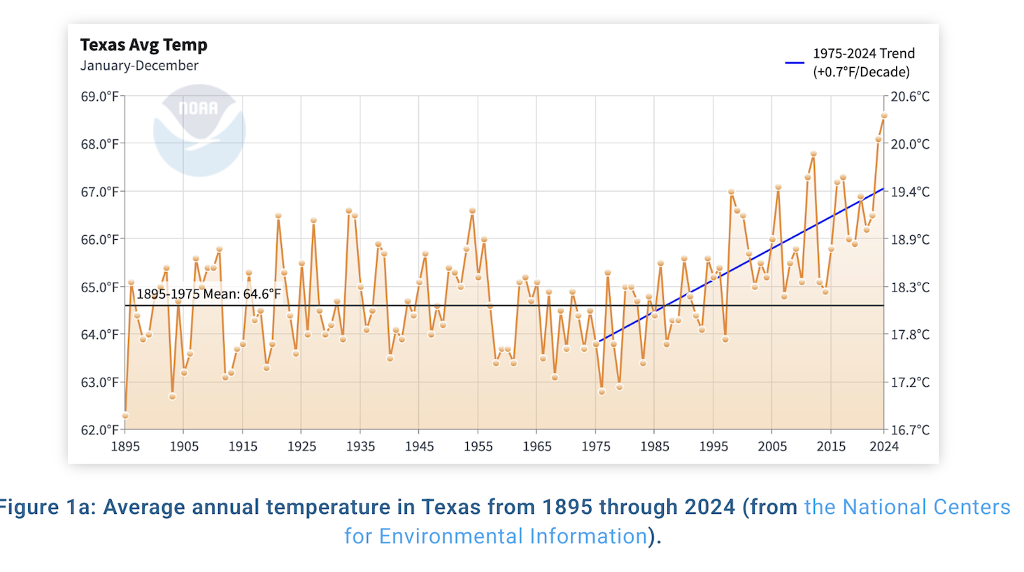
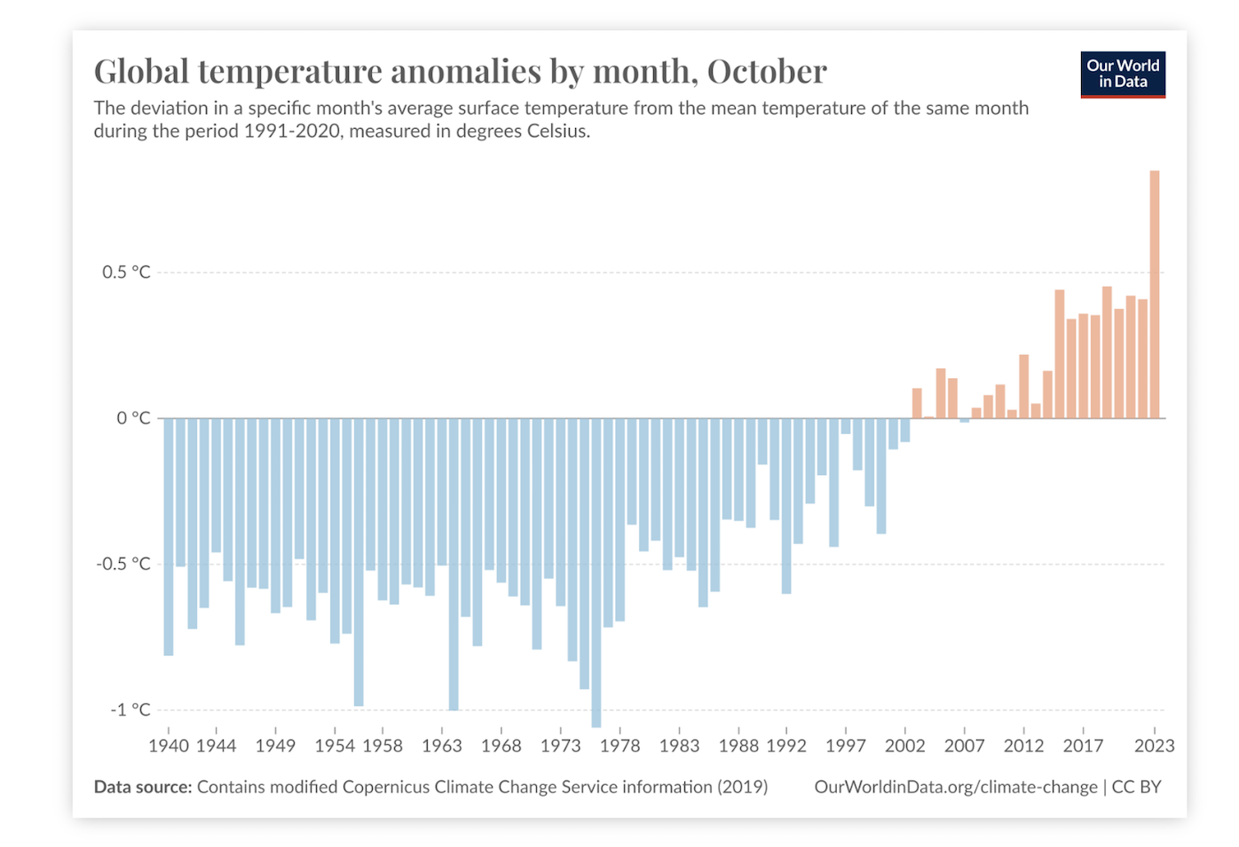
October was the warmest and driest October on record across the state of Texas. We are also tracking to have the warmest year on record, which would replace 2023 as the warmest. While some of the state saw some rain over the last week, in other areas of the state the predictions for rain did not pan out. According to the figure below, for the month of October, the entire state saw less than 25% of the normal amount of rain.
81% La Niña Conditions
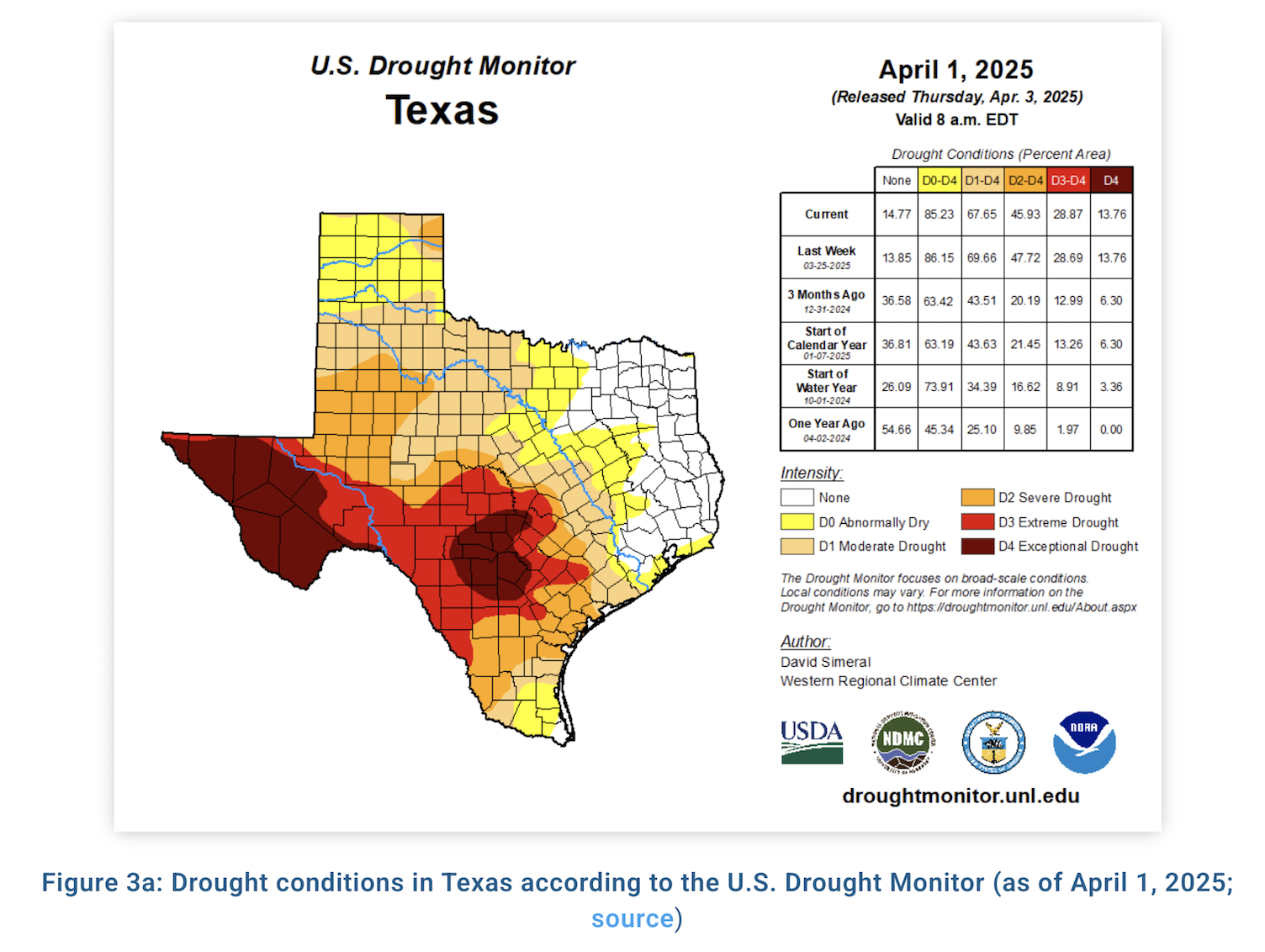
Pockets of drought relief exist, but not much. In fact, 74% of the state is abnormally dry or worse, up 4% from last month. Underlying dryness and dry, drought cured grasses will support low to moderate potential for wildfires with steady 10-15 mph winds as frontal activity increases. As forage transitions to fuel, rangeland managers are monitoring perennial grass response throughout the Concho Valley as some counties received over 12” of rainfall in September alone.
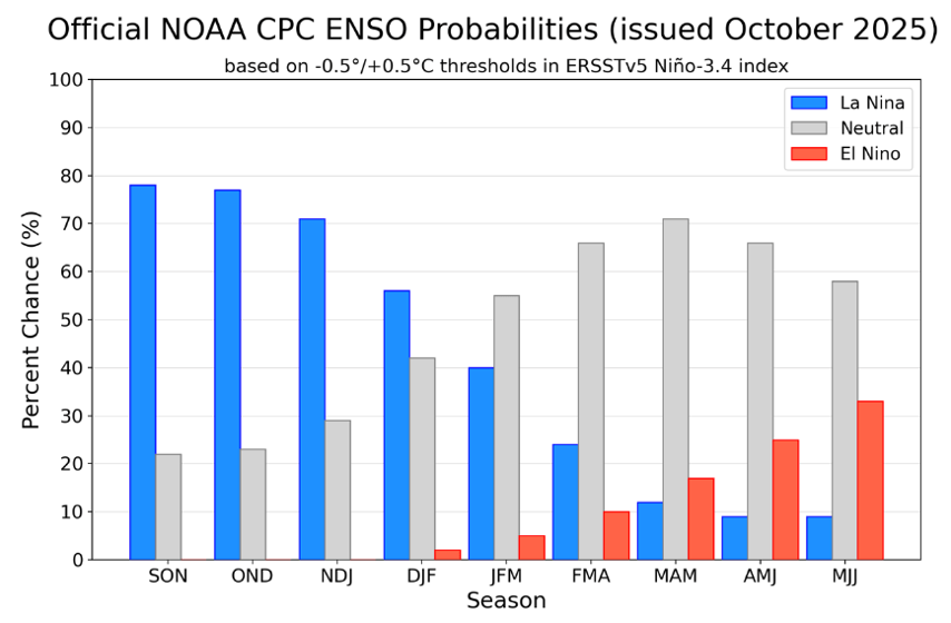
As we move from a summer to fall-like pattern this week, the Outlook +Water Report from October 5th keenly acknowledges sea-surface temperatures in the Central Pacific (defining the status of the weather phenomenon known as the El Niño Southern Oscillation) are under neutral conditions, but sea-surface temps continue to drop suggesting a transition to La Niña conditions in September-November (81% chance). However, current dynamical and statistical models show the La Niña period promises to be weak and short.
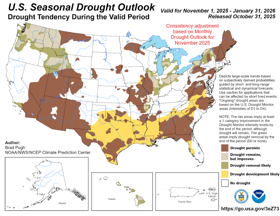
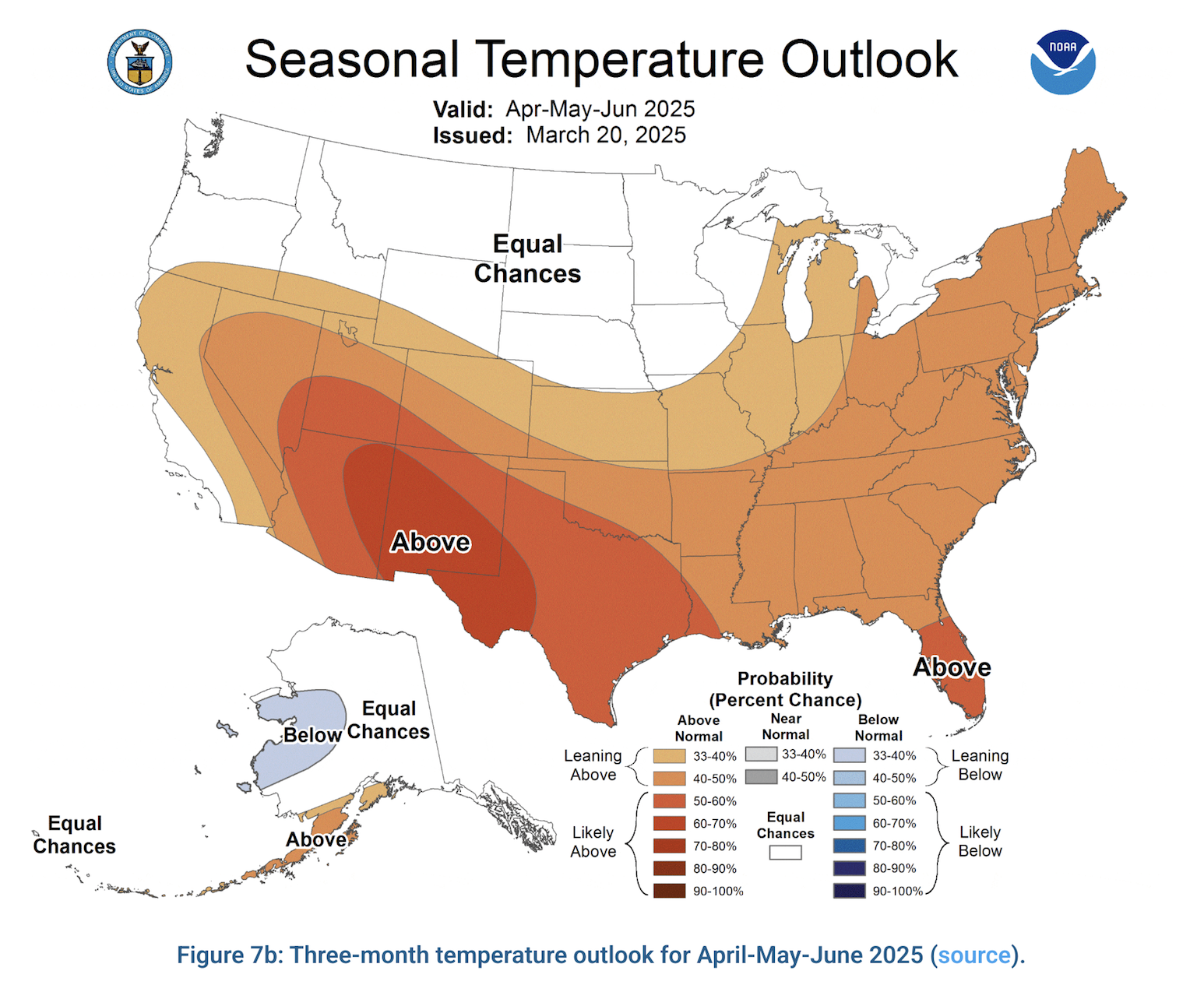
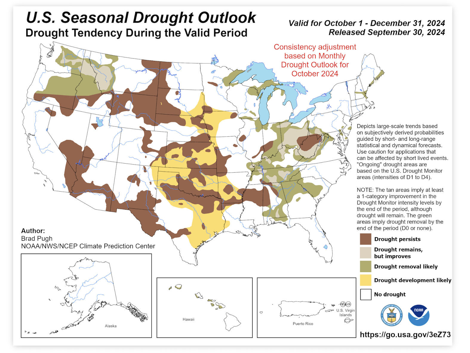
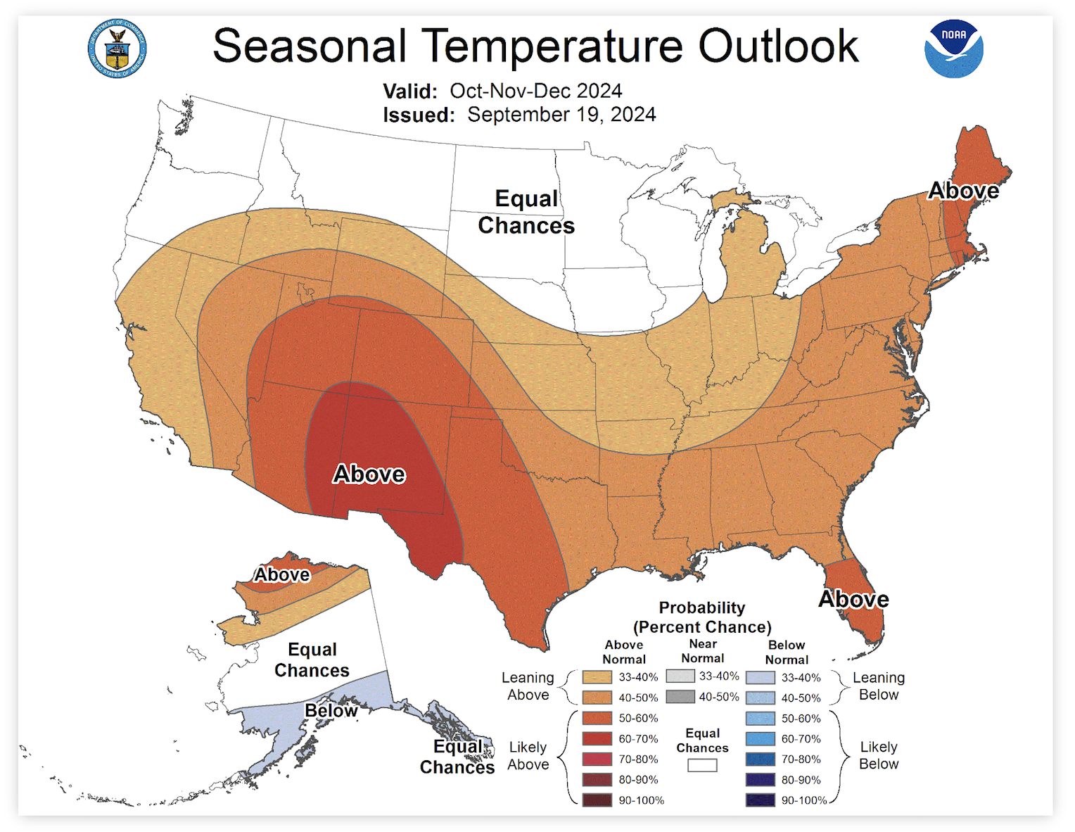
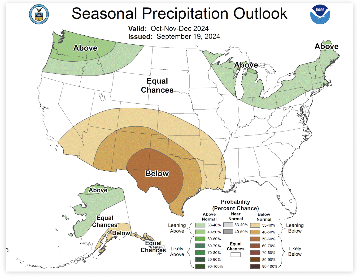
The current U.S. Seasonal Drought Outlook shows drought development over the eastern third of Texas and in the Panhandle. With the increased drought designation, temperatures over the next 3 months are expected to be above-average with rainfall deficits for Far West, Panhandle, and Eastern Texas.
As with any drought monitoring or transitions into La Niña this fall and winter, West Texas Rangeland managers know to prioritize keeping the ground covered, maintaining residual forage, rotating livestock, and plan, plan, plan.
For more information, be sure to check out the full article from Outlook + Water here!
Mace, R. (2024, October 8). outlook+water: Drought declines, La Niña delayed again, more drought expected. texaspluswater.wp.txstate.edu. October 14, 2024, https://texaspluswater.wp.txstate.edu/2024/10/08/outlookwater-drought-declines-la-nina-delayed-again-more-drought-expected/?utm_source=Texas%2BWater+Newsletter&utm_campaign=c569d9ca52-EMAIL_CAMPAIGN_2023_03_22_08_02_COPY_01&utm_medium=email&utm_term=0_-86323a7a46-%5BLIST_EMAIL_ID%5D&mc_cid=c569d9ca52&mc_eid=23994de06b
Drought and La Niña Update
Even with recent rains in the central part of Texas, drought conditions have, unfortunately, increased. There are moderate to severe droughts along the Northern border between Texas and Oklahoma and in the far West Texas region, drought conditions are extreme and in some areas have increased to exceptional drought. Central Texas, along the Gulf Coast, and parts of East Texas are looking above average showing no drought indicators.
Drought Update!
Did you know that East and Northeast Texas received two to four times the normal amount of rainfall in July? Unfortunately, the other half of the State did not do as well, as some places in West Texas only received a half an inch of rain. With the increase in rains in Eastern areas of the State, Lake Travis saw 78,000 acre-feet of runoff pour into the basin! Even with that amount of runoff, Lake Travis still remains at less than 50% full. The figure below shows the reservoir storage for Lake Travis. In looking at the figure, our numbers are above where we were for 2023 and a little bit more than where we were in 2011.
La Niña has been the dominant subject of the summer. According to this month’s update, projections are suggesting a shift to La Nina in mid-to-late summer. Looking at the figure below, there is a 45% chance that La Nina occurs during the July-August-September months. Moving ahead on the figure, we can see that shifting one month over, there is a 70% chance of those La Niña conditions occurring in August-September-October months.
Looking ahead at the three month drought outlook, you can see in the figure below, that West Texas will remain in drought conditions. There is also the possibility for drought conditions to develop in the Northern Panhandle.
In looking at the 3-month precipitation forecast, Texas does not look to be receiving a greater chance of rain. As you can see, the East Coast is set to have above normal chances of rain, with East Texas catching a tail end of that wave. On the other side of that, the Northern Panhandle is forecasted to receive less than normal rainfall. The figure below explains more of the 3-month forecast.
For more information, be sure to check out the full article here from Texas+Water.
Texas + Water – June Update
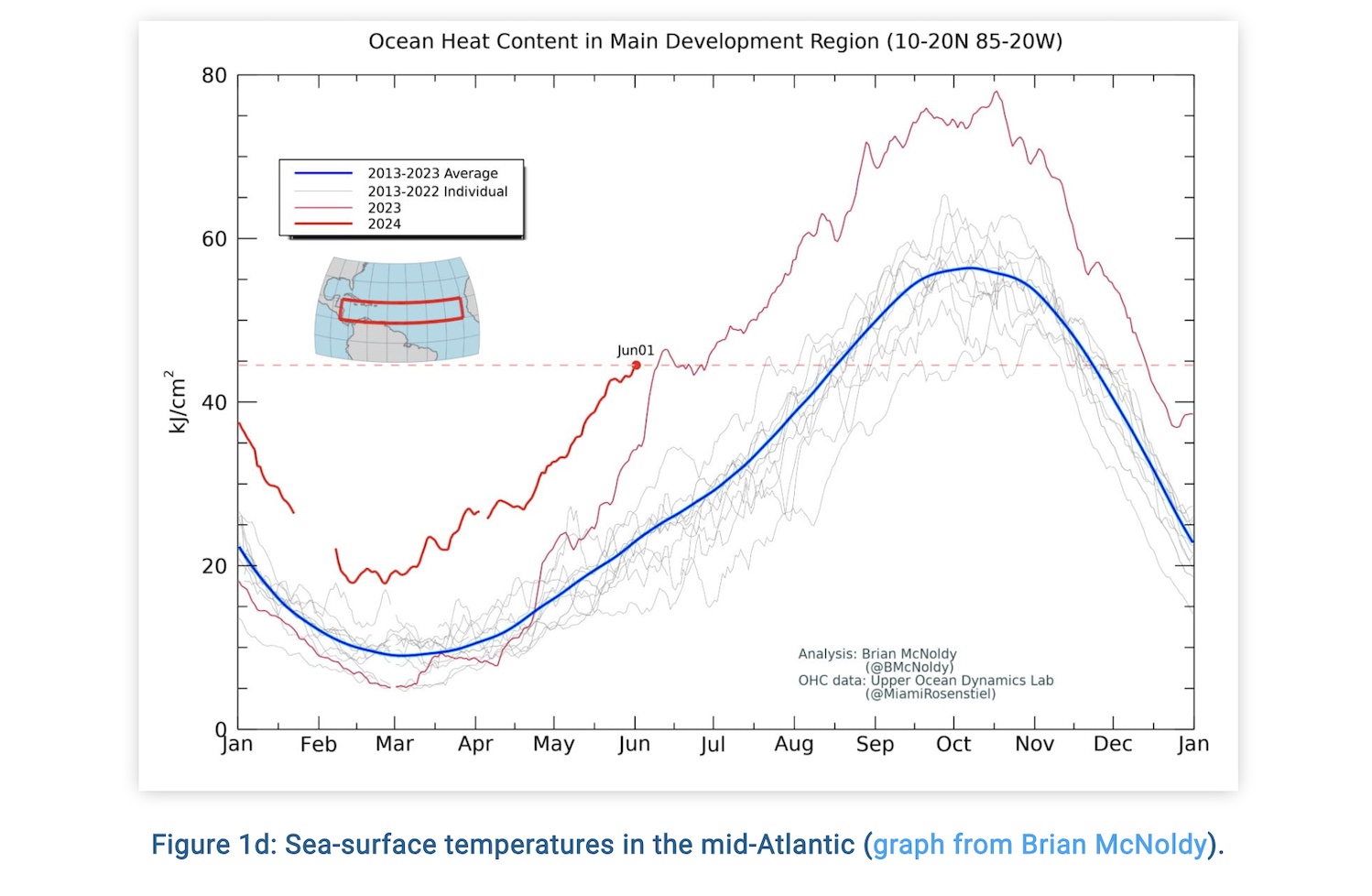
Hurricane season is coming fast and furious! NOAA is predicting an above-normal hurricane season, forecasting 17 – 25 named storms (winds higher than 39 mph), 8-13 hurricanes (winds of 74 mph or higher) and 4-7 major hurricanes (Cats 3, 4, or 5 with winds of 111 mph or higher). The sea-surface temperatures are already exceeding last year’s temperatures. The figure above shows the differences in temperatures from this year and previous years. With all this in mind, NOAA is predicting an 85% above-normal season. The season stretches from June 1st – November 30th.
Monthly Weather Update!
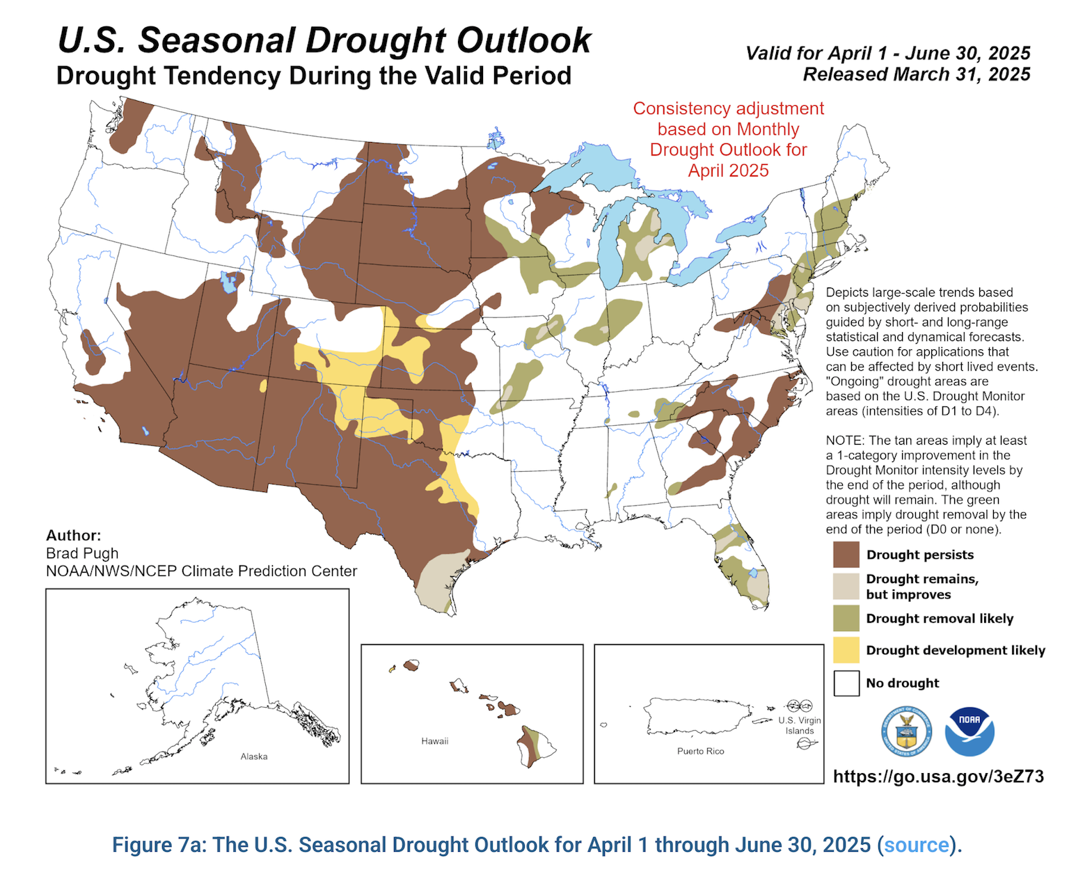
The U.S. Seasonal Drought Outlook was recently released for the next three months. According to the update released on March 31st, drought will persist in West Texas and with some improvements in the Hill Country area. The precipitation forecast will not help as the next three months is forecasted to be lower than normal rain chances while the very East side of the State will receive higher than normal rain chances. In Texas, 45% of the State is abnormally dry or worse, this has increased 2% from last month.
Drought Conditions Persist and a Weather Update!
Over the last month the Eastern part of the State has received significant amounts of rainfall, while the Western part of the State is below average. Over the next three months, see figure adjacent, it is predicted that the Western part of the State, which is already dry, will be experiencing even drier than average conditions.
[Read more…] about Drought Conditions Persist and a Weather Update!
What does a strong La Niña this summer mean for Texas weather?
During this Winter season, parts of Texas have experienced a strong El Niño presence. However, El Niño has begun to weaken and is expected to do so over the next few months. El Niño’s counterpart, La Niña, is likely to take over as early as this summer. According to the Climate Prediction Center, there is a 55% chance of La Niña conditions by June 1st.
[Read more…] about What does a strong La Niña this summer mean for Texas weather?