As stewards, let’s all just take a Christmas moment reflection and a deep breath of blue grama. Did you know that blue grama is the most common plant found throughout the mixed prairie? Even more impressively, blue grama possesses the most general distribution thriving as far north as Canada and as far south as Mexico.
A New Tool for Calculating Stocking Rates: StockSmart
StockSmart is a new decision support tool that is used for grazing management. StockSmart can be used to calculate stocking rates for cattle, horses, and sheep on any landscape.
[Read more…] about A New Tool for Calculating Stocking Rates: StockSmart
Cheatgrass in Texas Lower Rolling Plains
What is Cheatgrass? Cheatgrass (Bromus tectorum), is an invasive annual species. This species poses a significant ecological threat to the Southern Great Plains of Texas, particularly in the Rolling Plains Region. Cheatgrass will displace native grasses such as sideoats grama (Bouteloua curtipendula), blue grama (Bouteloua gracilis) and little bluestem (Schizachyrium scoparium). These dominant, perennial, native grasses are key to maintaining soil stability, biodiversity, and forage quality (D’Antonio & Vitousek, 1992; Chambers et al., 2014).
Wildfire Risk to Communities
What is Risk? Risk is the probability and consequences of uncertain future events. It is the framework for understanding the implications of decisions because the decisions we make all come with a tradeoff. Wildfire Risk is the likelihood of a wildfire occurring and the potential effects it would have on things we care about. Being able to estimate the likelihood and consequences of wildfires, we are better able to consider and plan for possible outcomes.
Getting to The Root of It
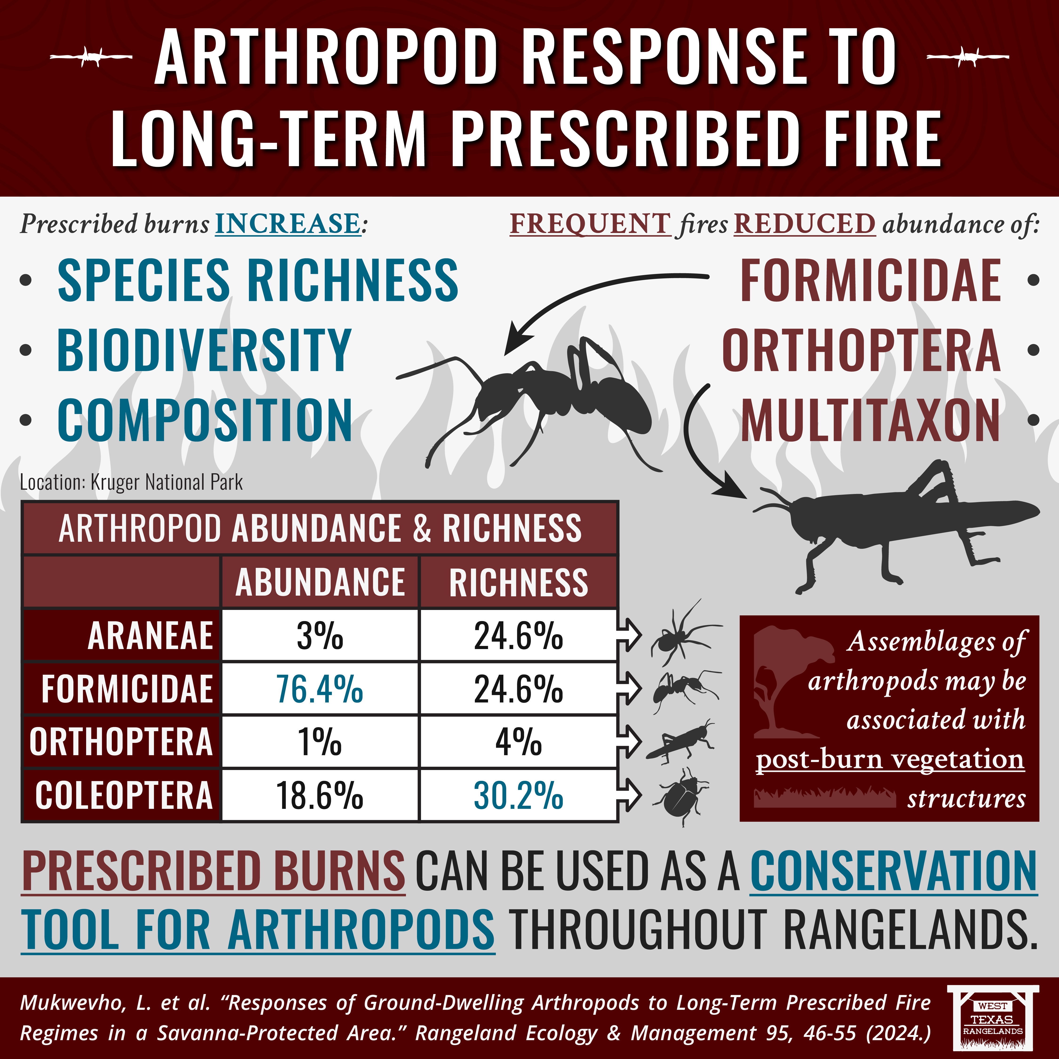
Interactions between plants and soils, plant-soil feedbacks (PSFs) are widely known to influence patterns of plant diversity at local and landscape scales. However, these interactions are rarely examined in the context of environmental factors. Prescribed fire is an environmental factor that alters microbial communities (Pourreza et al. 2014, Hedo et al. 2015, Prendergast-Miller et al. 2017). Prior to the study below, the influence of fire on PSFs was unexamined. Does fire affect PSF in woody legumes and what does it mean for Texas landowners? This study helped to answer this question by comparing soil microbial communities under living woody legumes, collected both within and outside of a burned area.
Is it Summer? Weather and Drought Update
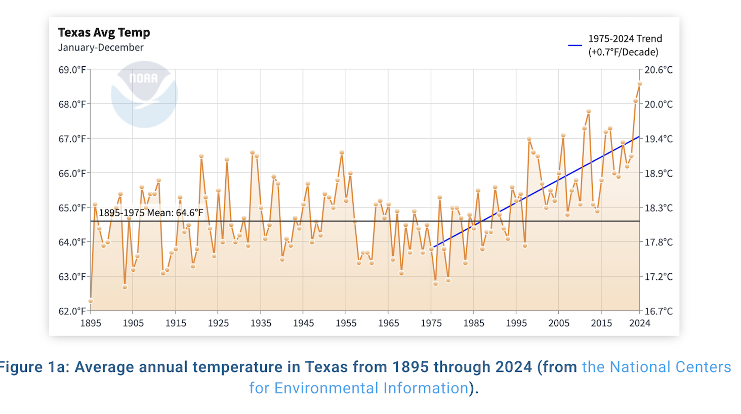
October was the warmest and driest October on record across the state of Texas. We are also tracking to have the warmest year on record, which would replace 2023 as the warmest. While some of the state saw some rain over the last week, in other areas of the state the predictions for rain did not pan out. According to the figure below, for the month of October, the entire state saw less than 25% of the normal amount of rain.
Portugal Wildfires and What Does That Have to do With Texas?
The Euro-Mediterranean region is a high fire prone area with 48,000 fires reported annually. The fires are the result of landscape fuel build up which has been driven by absentee land ownership, wildfire suppression policies, extreme temperatures, and extended droughts that simultaneously occur. This study used the LANDIS-II forest landscape model which is considered a fire-smart management tool. Fire-smart management is based on controlling fire regimes through landscape interventions to reduce hazardous fuels and foster fire-resistant/resilient landscapes. The study included assessing how alternative fire management strategies affect future landscape dynamics, the fire regulation capacity, and fire regimes under long-term absentee land ownership and extreme climate scenarios.
[Read more…] about Portugal Wildfires and What Does That Have to do With Texas?
Fire Weather Alert System and Wildfire Risk to Communities Resources from the U.S. Forest Service
The Fire Weather Alert System (FWAS) is a vital tool designed to support firefighters on the front lines by providing timely and critical weather information. This app is specifically designed to provide wildland firefighters alerts and notifications for changing weather conditions based on user-set thresholds. The app also provides convenient access to RAWS data, Zone Fire Weather Forecasts, and other important fire weather information.
Let’s Dance: Finding a Fire Rhythm for a Native Perennial Grass
As rangeland ecologists and managers, we are quick to produce definitive results after short-term treatments or management strategies. For example, many of our research studies revolve on the same timeline as graduate students. That in rangeland time, is pretty dang short. That’s why this study is so important. It is the first of its kind and it emphasizes just how crucial long-term research is, because what we think is the answer may just be the tip of the iceberg. There are certain rhythms to pick up on, especially after fire. We just need to stick around long enough with it, to find that rhythm.
[Read more…] about Let’s Dance: Finding a Fire Rhythm for a Native Perennial Grass
81% La Niña Conditions
Pockets of drought relief exist, but not much. In fact, 74% of the state is abnormally dry or worse, up 4% from last month. Underlying dryness and dry, drought cured grasses will support low to moderate potential for wildfires with steady 10-15 mph winds as frontal activity increases. As forage transitions to fuel, rangeland managers are monitoring perennial grass response throughout the Concho Valley as some counties received over 12” of rainfall in September alone.
As we move from a summer to fall-like pattern this week, the Outlook +Water Report from October 5th keenly acknowledges sea-surface temperatures in the Central Pacific (defining the status of the weather phenomenon known as the El Niño Southern Oscillation) are under neutral conditions, but sea-surface temps continue to drop suggesting a transition to La Niña conditions in September-November (81% chance). However, current dynamical and statistical models show the La Niña period promises to be weak and short.
The current U.S. Seasonal Drought Outlook shows drought development over the eastern third of Texas and in the Panhandle. With the increased drought designation, temperatures over the next 3 months are expected to be above-average with rainfall deficits for Far West, Panhandle, and Eastern Texas.
As with any drought monitoring or transitions into La Niña this fall and winter, West Texas Rangeland managers know to prioritize keeping the ground covered, maintaining residual forage, rotating livestock, and plan, plan, plan.
For more information, be sure to check out the full article from Outlook + Water here!
Mace, R. (2024, October 8). outlook+water: Drought declines, La Niña delayed again, more drought expected. texaspluswater.wp.txstate.edu. October 14, 2024, https://texaspluswater.wp.txstate.edu/2024/10/08/outlookwater-drought-declines-la-nina-delayed-again-more-drought-expected/?utm_source=Texas%2BWater+Newsletter&utm_campaign=c569d9ca52-EMAIL_CAMPAIGN_2023_03_22_08_02_COPY_01&utm_medium=email&utm_term=0_-86323a7a46-%5BLIST_EMAIL_ID%5D&mc_cid=c569d9ca52&mc_eid=23994de06b