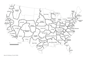
My colleague John Robinson sent me a link to What if the United States Were Shaped According to Economics? by Ross Pomeroy. It’s always fun to see our usual state borders distorted or color-coated, whether by GDP or status as a tourism destination.
Alasdair Rae and Garrett Nelson used American Community Survey commuting flows to identify functional economic regions. Pretty cool. Texas is broken into six states.
 It is important to think about the fact that this map is based on commuting patterns and not, say, spending patterns. I was surprised that western Kansas aligned with Kansas City rather than Denver. But the region also includes Wichita, and there are some companies, particularly related to energy and trucking that probably drive that commuting interconnectivity. If we were looking at spending, and especially medical spending, we would likely see stronger ties to Denver. Interestingly, there is divot in western Kansas that is aligned with Denver, and that is about the same area that moves back and forth between central and mountain time seasonally.
We also see the importance of commuting related to trucking, ag (probably mostly cattle feeding), and probably energy in the large Amarillo-Lubbock area that extends to southwest Kansas. When we look at the commuting patterns (below), we also see the importance of I-35 in connecting San Antonio and Austin. In a 2016 paper, Frye identifies traded sectors, including agriculture, mining, manufacturing, and wholesale trade, as those more affected by interstate highways. It is logical to assume these are also affected by commuting patterns reliant on highway transportation.
 Because there are fewer people in West Texas, up through the Great Plains, and in parts of the West, we also see few commuting connections and more open space. Maine is the nation’s most rural state, and we also see a large white area in northern Maine. But to wax poetic for a moment, the commuting map is a vibrant depiction of the US and the regions that form it. It is important a work-in-progress to have some open canvas.