Rain on a back door on Oct. 1, 2021. (Laura McKenzie/Texas A&M AgriLife Marketing and Communications)
The National Oceanic and Atmospheric Administration forecasts a shift from El Niño into neutral and eventually La Niña conditions this summer/fall. This week, we look at what this might mean for summer 2024 weather conditions on the Texas High Plains.
The El Niño-Southern Oscillation
The El Niño-Southern Oscillation (ENSO) describes a cycle of changes in ocean temperature and air pressure in the tropical Pacific Ocean. El Niño and La Niña are the extremes of this cycle.
In an El Niño, sea surface temperatures are warmer than average while the trade winds that blow across the Pacific Ocean weaken. For the Southern United States, the result is an increased chance of cooler and wetter winters.
On the opposite end of the ENSO cycle is La Niña. During a La Niña, sea surface temperatures are cooler than average and trade winds strengthen. La Niña is generally associated with warmer and drier winters in the Southern U.S.
Whether we are in El Niño or La Niña depends on both the atmospheric and oceanic conditions in the tropical Pacific Ocean. The atmospheric conditions are measured by the National Oceanic and Atmospheric Administration (NOAA) using the Southern Oscillation Index (SOI). Ocean temperatures are measured by NOAA using the Oceanic Niño Index (ONI). For either El Niño or La Niña to exist both the oceanic and atmospheric conditions need to be present. This article on the ENSO alert system explains the decision process the NOAA uses to determine ENSO status.
As of last month, we appear to be on the verge of a transition from El Niño to neutral conditions. The two questions now are, when will El Niño end and when will La Niña begin? While these questions are impossible to answer with certainty, the NOAA’s ENSO forecast team does provide some guidance. According to their predictions, there is a 90% chance of a transition to neutral in the May-June-July time frame. They also predict a 49% chance of a shift to La Niña in the June-July-August period. This chance increases to 69% for July-August-September, and to nearly 80% for August-September-October. At this time, it appears likely that La Niña will return by the end of summer.
Impacts of a Transition to La Niña
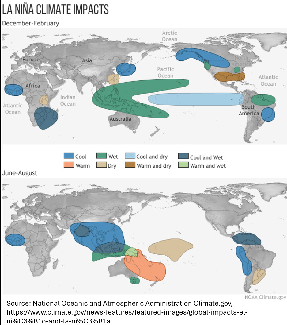
So, what does a return to La Niña mean for the Texas High Plains? La Niña is associated with warmer and drier winters, however its effect on summer and fall weather is less certain. Figure 1 illustrates this. The figure compares La Niña’s impact on climate in winter and summer and indicates no significant impact on summer climate for North America.

Figure 1. La Nina Climate Impacts
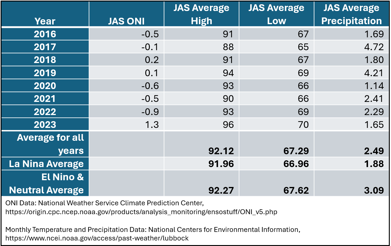
Looking at temperature and precipitation data for Lubbock, TX provides a more local look at the possible impact of a shift to La Niña. Table 1 reports the July-August-September (JAS) ONI values, along with the average high/low temperatures and precipitation for the same months for the years 2016-2023. During this time, there were four years where the ONI indicated La Niña and 4 years where the ONI indicated either El Niño or neutral conditions. We can compare the averages for the La Niña years to the average for the other years to get an idea on La Niña’s summer impact. It appears that La Niña has not had a large impact on summer temperatures in this part of the state. However, La Niña does seem to result in less precipitation, especially compared to summers when neutral conditions prevail.

Table 1. ENSO, temperature, and precipitation values for Lubbock, TX, 2016-2023
It seems reasonable to expect average summer temperatures and less-than-average precipitation should La Niña return this summer. How this impacts crop production in the Texas High Plains probably depends on the exact timing of La Niña’s return. A July or early August return could negatively impact crop progress if La Niña brings dry conditions to the region. However, a late August or September return could bring benefits to the region in the form of favorable fall harvest conditions.
The Current Climate Outlook
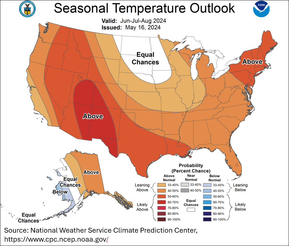
Temperature and precipitation are impacted by multiple factors, not just the ENSO state. With this in mind, here is a look at NOAA’s most recent 3-month climate predictions. Figure 2 shows NOAA’s predictions for temperature. As of May 16, there is a 50-60% chance of above normal temperatures for most of the Texas High Plains region during the June-July-August period. Based on NOAA’s methodology, this means that there is a 33% of normal temperatures during this period and a 7-17% chance of below normal temperatures.

Figure 2. NOAA temperature predictions, June-July-August
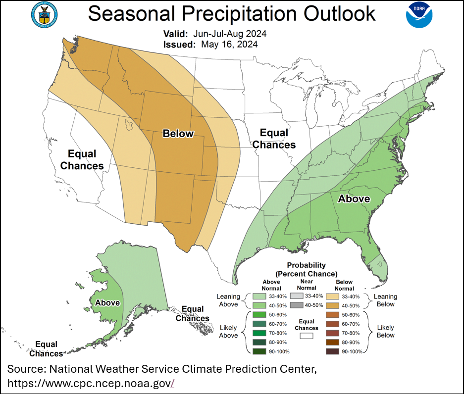
Figure 3 shows NOAA’s predictions for precipitation during the June-July-August period. According to the figure, there is a 40-50% chance of below normal precipitation for most of the region. Therefore, there is a 33% chance of normal precipitation and 17-27% chance for above normal precipitation.

Figure 3. NOAA precipitation predictions, June-July-August