The Lower Coast has been broken down into the following areas:
KINGSVILLE AREA
BUFFIN BAY
COASTAL SAND PLAIN SHEET
LAGUNA MADRE/PADRE ISLAND
SOUTH TEXAS BRUSH COUNTRY
RIO GRANDE DELTA
LOWER RIO GRANDE VALLEY
KINGSVILLE AREA
KING RANCH
Owner: Private 361/592-8055
Nearest Town: Kingsville Size: 825,000 acres
Wetlands: Estuarine- wind-tidal salt flats and salt marsh Prairie pothole and marsh- potholes and marshes (Santa Gertrudis Div.) Coastal sand sheet- interdunal depressions (Norias Unit)
Recreation/Education: Wildlife viewing, hunting, commercial nature tours
Description: Many freshwater wetlands associated with natural ponds, depressions, and drainages; also with stock tanks and wells. Extensive wind-tidal flats and salt marshes fringe the Laguna Madre. Various guided nature tours start at the Visitors Center. Various fees.
Directions: From Kingsville, take TX 141 about 3.5 mi. west of US 77 to VC.
SANTA GERTRUDIS CREEK BIRD SANCTUARY

Glossy ibis. (MICHAEL MURPHY, TEXAS DEPARTMENT OF TRANSPORTATION)
Owner: Kleberg County 361/595-8591
Nearest Town: Kingsville
Wetlands: Lower coast riparian- impounded floodplain marsh
Recreation: Wildlife viewing, hiking
Description: Site includes a stretch of creek bank, a leveed pond of several acres, and a large cattail marsh. You can walk along the levee to view the marsh. No fee.
Directions: From US 77 in Kingsville, go east about 1.5 mi. on FM 1717 to the creek.
BAFFIN BAY
DRUM POINT
Owner: Kleberg County 361/595-8591
Nearest Town: Riviera
Wetlands: Estuarine- tidal mud flats
Recreation: Wildlife viewing
Description: Drum Point is a bluff that overlooks Cayo del Grullo, a secondary bay of Baffin Bay. Extensive tidal mud flats are very attractive to shorebirds and wading birds. No fee or facilities.
Directions: From Kingsville, go about 11 mi. south on US 77 to FM 628. Go east 8.5 mi.
on 628 to Loyola Beach. Turn left (north) on CR 1132 and go to bluff; continue on caliche road to shoreline and point.
KAUFER-HUBERT MEMORIAL COUNTY PARK
Owner: Kleberg County 361/595-8591
Nearest Town: Riviera Size: 100 acres
Wetlands: Estuarine- tidal mud flats and salt marsh
Recreation: wildlife viewing, boating, fishing, picnicking, camping (adjacent)
Description: Just north of the main entrance, at the mouth of Vattmann Creek, are tidal mud flats and salt marshes. No fee. Seawind Campground (fee) is adjacent to the park.
Directions: From Kingsville, go 11 mi. south on US 77 to FM 628. Turn left and go about 8.5 mi. to Loyola Beach. Continue southeast on 628 to park.
COASTAL SAND PLAIN SHEET
LOUISE TRANT BIRD SANCTUARY
Owner: Audubon Outdoor Club of Corpus Christi
Nearest Town: Riviera Size: 2+ acres
Wetlands: Coastal sand sheet- marsh in natural depression
Recreation: wildlife viewing
Description: A cattail marsh in a 2-acre, ephemeral pothole that is dependent upon rainfall and groundwater level. Good birding for marsh and wading birds. No facilities or fee.
Directions: On the east side of US 77, just north (0.1 mi.) of Riviera in Kleberg County.
KENEDY RANCH
Owner: John G. & Marie Stella Kenedy Memorial Foundation
Nearest Town: Sarita Size: 235,000 acres
Wetlands: Coastal sand sheet- interdunal marsh Estuarine- wind-tidal salt flats
Recreation: educational nature tours
Description: The ranch has typical Coastal Sand Plain freshwater wetlands in potholes and interdunal swales. The ranch borders the Laguna Madre at the Land Cut where extensive wind-tidal flats with blue-green algae mats occur. Guides that have been certified by the ranch facilitate organized tour groups. Sanborn’s Travel Service of Corpus Christi (1-877-253-6339) books all group tours on the ranch. There is a marsh in Sarita on Garcia Rd.; a boardwalk, blind, and picnic area are planned.
Directions: Foundation field office is at 101 E. LaParra Ave. in Sarita, Kenedy County, on US 77 about 22 mi. south of Kingsville. To see the marsh, go west on LaParra to Garcia, turn left and go 0.2 mi. Marsh is on the left.
TxDOT FALFURRIAS REST AREA
Owner: Texas Dept. of Transportation
Nearest Town: Falfurrias
Wetlands: Coastal sand sheet- constructed demonstration marsh
Recreation: wildlife viewing, picnicking, rest area facilities
Description: The demonstration wetland is in a constructed pond that is continuously supplied with water. Wetland plants include cattail, arrowhead, and duckweed. This is not a natural wetland, but it is a good place to see dragonflies and damselflies. No fee.
Directions: From Falfurrias in Brooks County, go south about 6 mi. on US 281 to the rest area on the right.
LAGUNA MADRE / PADRE ISLAND
PADRE ISLAND NATIONAL SEASHORE
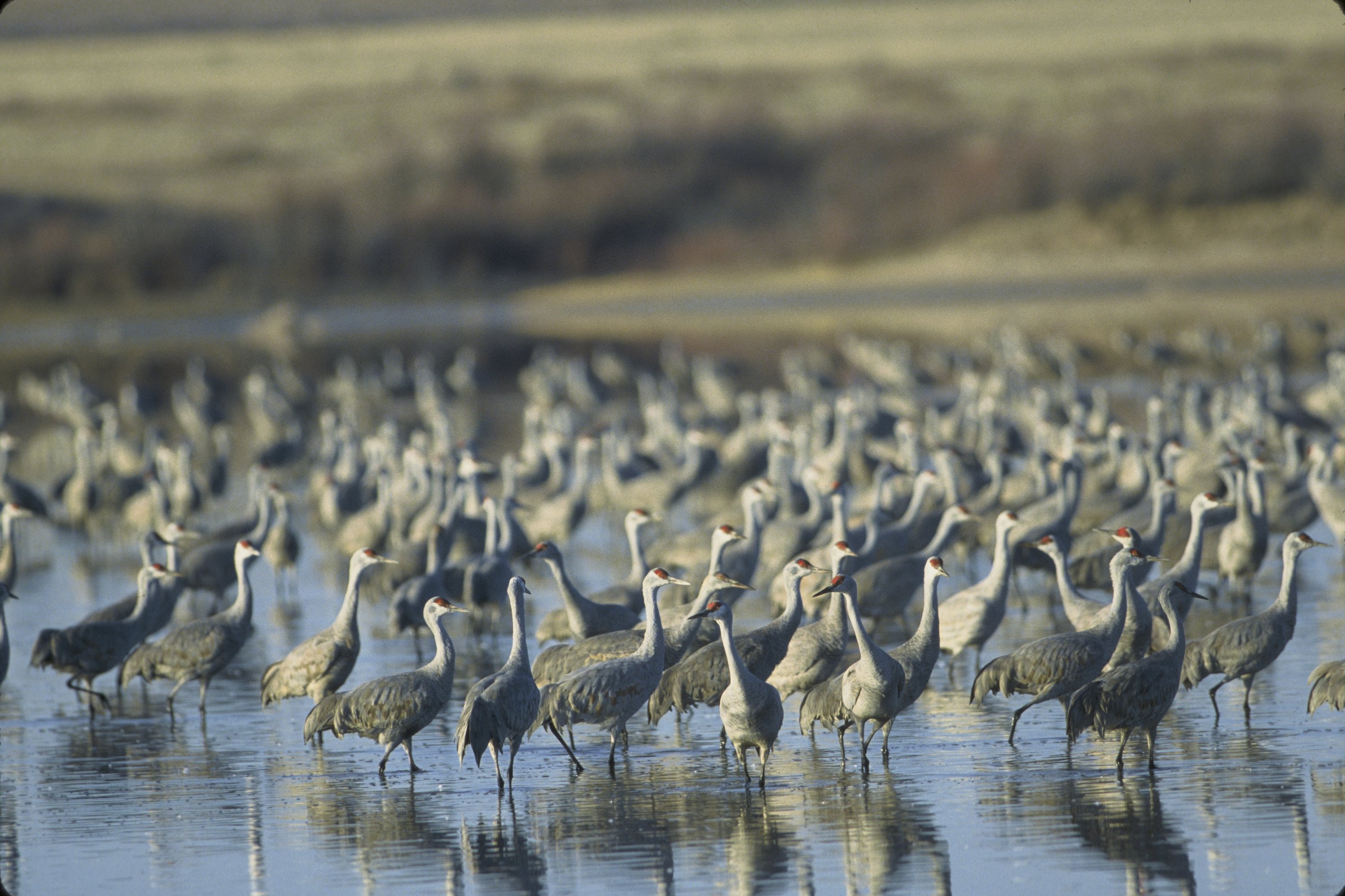
Sandhill Cranes. (Source: USFWS)
Owner: National Park Service 361/949-8068
Nearest Town: Corpus Christi Size: 133,000 acres![]()
Wetlands: Estuarine- tidal salt marshes and flats
Barrier island interior- marshes in interdunal and central-flats depressions
Recreation/Education: wildlife viewing, beach activities, boating, camping, hiking/biking, fishing, interpretive programs/displays/trail, 4×4 driving area, hatchling sea turtle release program
Description: Longest remaining undeveloped barrier island in the world. Visitor Center has exhibits and programs. During the school year, interpretive programs are geared toward environmental education for school kids. The park is always open. VC open 9-4 in winter, extended hours in summer. Entrance fee and use fees. Marshes can be viewed along Bird Island Basin Rd., 2.6 miles north of the VC, as well as along Park Rd. 22. Estuarine marshes best viewed at Yarborough Pass (4-wheel drive required). Contact VC for hatchling sea turtle release schedule.
Directions: From Corpus Christi, take South Padre Island Dr. (TX 358) east and cross JFK Causeway (Park Rd. 22). Continue 10 mi. south on PR 22 to entrance.
PORT MANSFIELD NATURE TRAIL
Owner: Willacy County Navigation District 956/944-2325
Nearest Town: Port Mansfield Size: 200 acres
Wetlands: Coastal sand sheet- nontidal brackish marsh
Recreation: wildlife viewing, hiking
Description: The nature trail is 1.5 miles and crosses several habitat types including about 15 acres of ephemeral freshwater marsh supporting brackish marsh plants (due to soil salinity). No facilities, hours, or fee. Fred Stone County Park, about 1 mile away, has restrooms. On the way to Port Mansfield, TX 186 crosses the Coastal Sand Sheet and numerous potholes and swales with fresh and inland brackish marshes (all private property).
Directions: From US 77 in Raymondville, go east about 24 mi. on TX 186 to Port Mansfield. Nature trail is across from TPWD public boat ramp.
LAGUNA ATASCOSA NATIONAL WILDLIFE REFUGE
Owner: U.S. Fish & Wildlife Service 956/748-3607
Nearest Town: Rio Hondo Size: 45,187 acres
Wetlands: Estuarine- tidal and wind-tidal mud flats; tidal salt marsh Lower coast riparian- marsh and woods fringing ponds and resacas
Recreation/Education: wildlife viewing, hiking/biking, auto tours, interpretive exhibits and videos, guided programs and tours
Description: The refuge impounds freshwater in ponds, resacas, and the central Laguna Atascosa (“muddy lake”). Two auto tour roads are open sunrise-sunset, daily. Six nature trails through various habitats. Visitor Center open 10-4 daily, Oct.-Apr.; 10-4, weekends in May; closed June-Sept. Schools and other groups may call to arrange programs. Entrance fee, education groups may qualify for free entry.
Directions: From Harlingen, go east 14 mi. on FM 106 past Rio Hondo. Go left at the T (Buena Vista Rd.) and go 3 mi. to VC.
LAGUNA MADRE NATURE TRAIL (ANDY BOWIE PARK)
Owner: City of South Padre Island 956/761-4412
Nearest Town: South Padre Island Size: 4 acres
Wetlands: Barrier island interior- marsh (treated effluent)
Recreation/Education: wildlife viewing, hiking, interpretive trail
Description: This marsh is sustained by freshwater effluent from a wastewater-treatment plant. Brackish marsh plants like southern cattail and bulrushes dominate. A 1,500-foot boardwalk, with interpretive signs, crosses the 4 acres of wetlands. This marsh is excellent for viewing rails. A tidal saltmarsh cordgrass marsh, uncommon along the Laguna Madre, is found bayward of the brackish marsh. Always open, no fee. Also, at the rear of the Convention Center is a viewing area for mud flats and low dunes.
Directions: In South Padre Island, go 4.5 mi. north of Queen Isabella Causeway on Park Rd. 100 (Padre Blvd.) to the Convention Center at 7355 Padre Blvd., on Orca Circle across from Andy Bowie County Park.
QUEEN ISABELLA CAUSEWAY WETLANDS
Owner: Texas General Land Office
Nearest Town: South Padre Island
Wetlands: Estuarine- tidal black mangrove, saltmarsh, and mudflats
Recreation: wildlife viewing, hiking
Description: At the east end of the causeway on South Padre Island, on both sides of the turnaround, are tidal mudflats fringed by black mangrove and some regionally uncommon saltmarsh cordgrass marshes. Some of the most accessible, and largest, black mangroves we know of. A boardwalk into the mangroves, on both sides of the causeway, was built with TxDOT funds, as part of the Island Gateway Beach-To-Bay Alternative Transportation Loop.
SOUTH TEXAS BRUSH COUNTRY
USFWS LA SAL VIEJA TRACTS
Owner: U.S. Fish & Wildlife Service 956/787-3079 x 100
Nearest Town: Raymondville Size: East Lake=1,755 acres; Teniente=5,637 acres
Wetlands: Lower coast potholes and marshes- inland saline flats and marsh
Recreation: wildlife viewing, hiking
Description: La Sal Vieja (“the ancient salt”) consists of two large salt lakes, and many smaller potholes, on the southern edge of the Coastal Sand Plain. The East Lake and Teniente tracts are units of the Lower Rio Grand Valley National Wildlife Refuge, as is site are sites 14, 17, and 18. In some areas fringing the lakes, spring flows support brackish marshes with southern cattail and bulrushes. High brackish marsh is found on the salt flats around the lakes. Open daily sunrise to sunset. Foot access only; no fee.
Directions: From Raymondville, go west 4 mi. on TX 186 to FM 1761. Go north on 1761 about 2.7 mi. to where the road turns sharply east. Continue north on the county road for 0.6 mi., then left for 0.4 mi. to the info. kiosk at the East Lake tract. To go to the Teniente tract, return to 186 and go west about 8.8 mi. (about 2.4 mi. past the junction with FM 88) to the third of three county roads that go north into the tract. Go north about 2.6 mi. to the Teniente tract info. kiosk.
Directions: From Port Isabel, take the Queen Isabella Causeway (Park Rd. 100) to its east end at South Padre Is.
USFWS LA SAL DEL REY TRACT
Owner: U.S. Fish & Wildlife Service 956/787-3079 x 100
Nearest Town: Raymondville Size: 6,910 acres
Wetlands: same as La Sal Vieja
Recreation: wildlife viewing, hiking
Description: La Sal del Rey (“the King’s salt”), in Hidalgo County, is another salt lake just west of La Sal Vieja, and with similar habitats including scattered potholes. Open daily sunrise to sunset. Foot access only, no fee.
Directions: From the westernmost of the three county roads into the Teniente tract, go west about 6.4 mi. on TX 186 to the info. kiosk on the right side of the road.
DELTA LAKE COUNTY PARK
Owner: Delta Irrigation District
Manager: Hidalgo County Precinct 1 956/262-6585
Nearest Town: Elsa Size: 65 acres
Wetlands: Lower coast potholes and marshes- marsh fringing reservoir
Recreation: wildlife viewing, hiking, picnicking, park facilities
Description: Delta Lake is a 2,200-acre irrigation water reservoir. Shoreline sloughs support marshes of cattails and bulrushes. Day use only; no fee. Group camping is permitted by special arrangement.
Directions: From US 281 in Edinburg, go east about 10 mi. on TX 107 to Elsa. Go north (left) on FM 88 about 8.5 mi. to park entrance on the right. From Raymondville in Willacy County, go west about 10.5 mi. on TX 186 to FM 88. Go south (left) 4.8 mi. on 88 to park entrance on the left.
EDINBURG MUNICIPAL PARK SCENIC WETLAND

Source: Edinburg Scenic Wetland
Owner: City of Edinburg 956/381-5631
Nearest Town: Edinburg Size: 40 acres
Wetlands: Lower coast potholes and marshes- treatment-plant marsh
Recreation: wildlife viewing, hiking
Description: Cattail marsh is supported by effluent from a wastewater-treatment plant. One-mile nature trail has 6 marsh observation blinds. Open during daylight hours, no fee.
Directions: From the junction of TX 107 (University) and US 281 on the east side of Edinburg, go east about 1.1 mi. on 107 to Doolittle Rd. Go right (south) on Doolittle about 0.5 mi. to entrance.
USFWS MONTE CRISTO TRACT
Owner: U.S. Fish & Wildlife Service 956/787-3079 x 100
Nearest Town: Edinburg Size: 2,701 acres
Wetlands: Lower coast potholes and marshes- marsh fringing potholes
Recreation: wildlife viewing, hiking
Description: This Hidalgo County tract is on the extreme southern edge of the Coastal Sand Plain and has some potholes on it. The two potholes in the northeast corner of the tract are used as irrigation water reservoirs and support fringing wetlands. Open daily sunrise to sunset. Foot access only, no fee.
Directions: From Edinburg, take US 281 north to FM 1925. Go west on 1925 about 7.5 mi. to Wallace Rd. Go north 3.5 mi. on Wallace Rd. to info. kiosk on the left.
RIO GRANDE DELTA
USFWS BOCA CHICA TRACT
Owner: U.S. Fish & Wildlife Service 956/787-3079 x 100
Nearest Town: Brownsville Size: 17,255 acres
Wetlands: Estuarine- wind-tidal salt flats and salt marsh
Recreation: wildlife viewing, fishing, hiking
Description: Part of the Boca Chica subdelta of the Rio Grande. This largest unit of the Lower Rio Grande Valley National Wildlife Refuge is contiguous with South Bay and Boca Chica SP. Vehicles allowed on “fishing access roads” only; two roads go to Rio Grande, one to Brownsville Ship Channel. Other areas open to foot traffic only. Open every day, sunrise to sunset; no fee. Brush-covered lomas (clay dunes) can be seen from the highway on the salt flats.
Directions: From US 77/83 in Brownsville, take Boca Chica Blvd. east 1.5 mi. Boca Chica becomes TX 4; continue east for about 15 mi. to the info. kiosk near the Texas State Historical Marker.
SOUTH BAY COASTAL PRESERVE
Owner: Texas General Land Office
Manager: Texas Parks & Wildlife Dept. 512/389-4639
Nearest Town: Brownsville Size: 3,500 acres
Wetlands: Estuarine- wind-tidal salt flats with fringing black mangrove and salt marsh
Recreation: wildlife viewing, fishing, waterfowl hunting
Description: Preserve consists of the open water of the bay and intertidal flats. Black mangrove fringes the shoreline in many places and extensive seagrass beds are found in the bay waters. Boat access is off the Brownsville Ship Channel. In many areas, mats of blue-green algae cover the wind-tidal flats. The bay supports a small commercial eastern oyster fishery. Cruises of the Laguna Madre and South Bay offered by Colley’s Cruises in SPI (956/943-2473, http://www.fin2feather.com).
Directions: By boat, off the Brownsville Ship Channel out of Port Isabel. From Brownsville, take TX 4 east 22.5 mi. to Boca Chica State Park, which borders the southeastern corner of the bay.
BOCA CHICA STATE PARK
Owner: Texas Parks & Wildlife Dept. 956/585-1107
Nearest Town: Brownsville Size: 1,054 acres
Wetlands: Estuarine- wind-tidal salt flats and black mangrove
Recreation: wildlife viewing, beach activities, fishing, primitive camping
Description: This undeveloped park borders the south shore of South Bay, which is fringed by black mangrove that dies back whenever there is a freeze. From the end of TX 4, one can drive south along the beach to the mouth of the Rio Grande or north to Brazos Santiago Pass and the Brownsville Ship Channel. No facilities or fees; always open.
Directions: From US 77/83 in Brownsville, take Boca Chica Blvd. east 1.5 mi. Boca Chica becomes TX 4; continue east for 21 mi. to the end of TX 4 and the beach.
LOWER RIO GRANDE VALLEY
SABAL PALM AUDUBON CENTER & SANCTUARY

Source: Audubon Society
Owner: Texas Audubon Society 956/541-8034
Nearest Town: Brownsville Size: 527 acres
Wetlands: Lower coast riparian- woodlands fringing Rio Grande and resaca
Recreation/Education: wildlife viewing, hiking, tours, presentations and workshops, special events, interpretive displays
Description: A remnant grove of native, riparian sabal palms (Texas palmetto), once more widespread in the lower Rio Grande Valley. Three self-guided nature trails, trail guides may be purchased at the Visitors Center. VC open 9-5, Tues.- Sun., Oct.-May; June-Sept., Sat./Sun. only. Trails open year-round sunrise to sunset. Entrance fees vary.
Directions: From US 77/83 in Brownsville, at the end of the Freeway, turn left onto International Blvd. Go 0.75 mi., turn right onto Southmost Rd. (FM 1419). Go 6 mi. on 1419 and look for entrance on the right.
LAS PALOMAS WILDLIFE MANAGEMENT AREA
Owner: Texas Parks & Wildlife Dept. 956/565-1223
Wetlands: Lower coast riparian- woodlands fringing resacas
Recreation: wildlife viewing, hiking, hunting (except Voshell unit)
Description: The Las Palomas WMA has 3311 acres of land purchased to preserve native brush nesting habitat, some farmland and wetlands for white-winged doves. The Las Palomas WMA is comprised of 18 units in Cameron, Hidalgo and Presido counties of the Lower Rio Grande Valley. The tracts range in size from two acres to 604 acres.
Directions: The Las Palomas WMA is composed of numerous units in the Lower Rio Grande Valley. Please call the Area Manager for specific directions.
VOSHELL UNIT
Owner: Texas Parks & Wildlife Dept. 956/447-2704
Wetlands: Lower coast riparian- woodlands fringing resacas
Recreation: wildlife viewing, hiking, hunting (except Voshell unit)
Nearest Town: Brownsville Size: 66 acres
Description: A small tract bordered on the west and north by Resaca de la Palma. Riparian trees and brush fringe the resaca. No facilities or potable water. Contact headquarters for access info.
Directions: From US 77/83 in Brownsville, at the end of the Freeway, turn left onto International Blvd. Go 0.75 mi., turn right onto Southmost Rd. (FM 1419). Go 2.8 mi. and turn left onto FM 511. Go about 0.5 mi., area is on left after crossing Resaca de la Palma. No developed parking area.
RESACA DE LA PALMA / BRASIL UNITS
Owner: Texas Parks & Wildlife Dept. 956/447-2704
Wetlands: Lower coast riparian- woodlands fringing resacas
Recreation: wildlife viewing, hiking, hunting (except Voshell unit)
Nearest Town: Brownsville Size: 1,175 acres
Description: Resaca de la Palma meanders through the units. Old Carmen Ave. crosses the resaca once just south of unit’s south boundary, and twice within the units.
Directions: From US 77/83 in Brownsville, go west on TX 48 (Boca Chica) 1.3 mi. to Business 77. Continue west on US 281 (Military Highway) 4.6 mi. to Old Carmen Ave. Turn right (north) on Carmen, go 1.1 mi. to entrance.
EBONY UNIT
Owner: Texas Parks & Wildlife Dept. 956/447-2704
Wetlands: Lower coast riparian- woodlands fringing resacas
Recreation: wildlife viewing, hiking, hunting (except Voshell unit)
Nearest Town: Harlingen Size: 268 acres
Description: The unit is mostly farmland but has two interior resacas with riparian brush (such as Texas ebony) and trees. There is a parking area, information kiosk, and observation platform. Day use; contact headquarters for access info.
Directions: From US 77/83 in Harlingen, go 6.5 mi. south on FM 1479 (Rangerville Hwy.) to Jimenez Rd. (unpaved). Turn left on Jimenez, go 0.5 mi. to parking area on the right.
LLANO GRANDE LAKE
Owner: City of Weslaco
Nearest Town: Weslaco
Wetlands: Lower coast riparian- woodlands fringing resaca
Recreation: wildlife viewing, fishing, hiking
Description: Llano Grande Lake is a large resaca in the Main Floodway just south of Weslaco. There are parking areas to access the resaca on both ends of the FM 1015 bridge. Good riparian woods and brush, plus the permanent water of the resaca, provide good birding. No facilities, no fee. Site will eventually have a World Birding Center interpretive center.
Directions: From US 83 just east of Weslaco, go south about 2.5 mi. on FM 1015 to the Main Floodway and Llano Grande Lake. There is a large parking area at the south end of the bridge on the left.
SANTA ANA NATIONAL WILDLIFE REFUGE
Owner: U.S. Fish & Wildlife Service 956/787-3079
Nearest Town: Alamo Size: 2,088 acres
Wetlands: Lower coast riparian- woodlands along Rio Grande, marshes fringing lakes and resacas
Recreation/Education: wildlife viewing, hiking/biking, interpretive programs and displays, roving guides and naturalists, auto tour, interpretive tram tour
Description: On the Rio Grande in Hidalgo County. Twelve miles of trails (open sunrise to sunset) with roving naturalists during winter. Seven-mile drive open to cars. From Thanksgiving – Mar. there is an interpretive tram (fee) along the drive. Refuge and Visitors Center open every day except Christmas and Thanksgiving New Years Day. The Friends of the Wildlife Corridor operate interpretive canoe trips on the Rio Grande along the refuge.
Directions: From McAllen, go east 6 mi. on US 83 to FM 907. Turn south on 907 and go 7 mi. to US 281. Go east 0.25 mi. on 281 to entrance.
ANZALDUAS DAM & COUNTY PARK
Owner: International Boundary Waters Commission
Manager: Hidalgo County Precinct 3 956/585-4509
Nearest Town: Mission Size: 70 acres
Wetlands: Lower coast riparian- woodlands fringing Rio Grande and resaca
Recreation: wildlife viewing, fishing, hiking, picnicking, park facilities
Description: The park is at the Anzalduas Dam on the Rio Grande. There is also a resaca. Riparian woodlands fringe the river and resaca. Day use only; no fee during the week. Entrance fee (vehicle fee) on weekends.
Directions: From Mission, go south on TX 107 (Conway) to US 83 where 107 becomes FM 1016. Go south 2.9 mi. on 1016 to FM 494. Turn right onto 494 and go 1.3 mi. to park entrance on the right.
BENTSEN-RIO GRANDE VALLEY STATE PARK

Source: TPWD
Owner: Texas Parks & Wildlife Dept. 956/585-1107
Nearest Town: Mission Size: 588 acres
Wetlands: Lower coast riparian- woodlands fringing Rio Grande and resaca
Recreation/Education: wildlife viewing, camping, hiking/biking, boating, fishing, picnicking, nature study, guided tours
Description: The park is on the Rio Grande in Hidalgo County. The subtropical riparian woodlands consist of cedar elm, hackberry/sugarberry, ash, ebony, anaqua, and tepequaje. Two nature trails; guided tours daily Dec.- Mar. (fee). Open every day year-round (7am-10pm). Entrance and use fees. Headquarters of the World Birding Center.
Directions: From Mission, go west 3 mi. on US Business 83 (Loop 374); then south on FM 2062 (Bentsen) for 2.6 mi. Enter on Park Rd. 43.
