County Migration Flows Mapping Tool

Last week I mentioned a New York Times graphic describing state-level migration flows. The Census Bureau has released the Census Flows Mapper, a county-level mapping tool. This is a useful tool for county leaders and economic developers as they think about who they are attracting, where out-migrants are going, and how they can leverage regional assets to support regional and local development. Statistically, most moves occur relatively near a base county, which alludes to the regional nature of our economies and social capital.

2008-2012 Net Migration in Brazos County, home to Texas A&M University’s main campus:
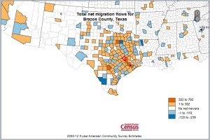
Brazos County TX image from Census Flows Mapper. http://flowsmapper.geo.census.gov/flowsmapper/map.html

Brazos County TX image from Census Flows Mapper. http://flowsmapper.geo.census.gov/flowsmapper/map.html

About Rebekka Dudensing

Dr. Rebekka Dudensing is an Associate Professor and Extension Economist - Community Economic Development with Texas AgriLife Extension and Research in the Department of Agricultural Economics at Texas A&M. Her research interests include the evaluation of economic development opportunities, taxation and public/private goods issues, entrepreneurship, and regional economic cooperation.
This entry was posted in Planning, Regionalism, Resources and tagged , . Bookmark the permalink.

Leave a Reply

Your email address will not be published. Required fields are marked *